Expoziție Temporară
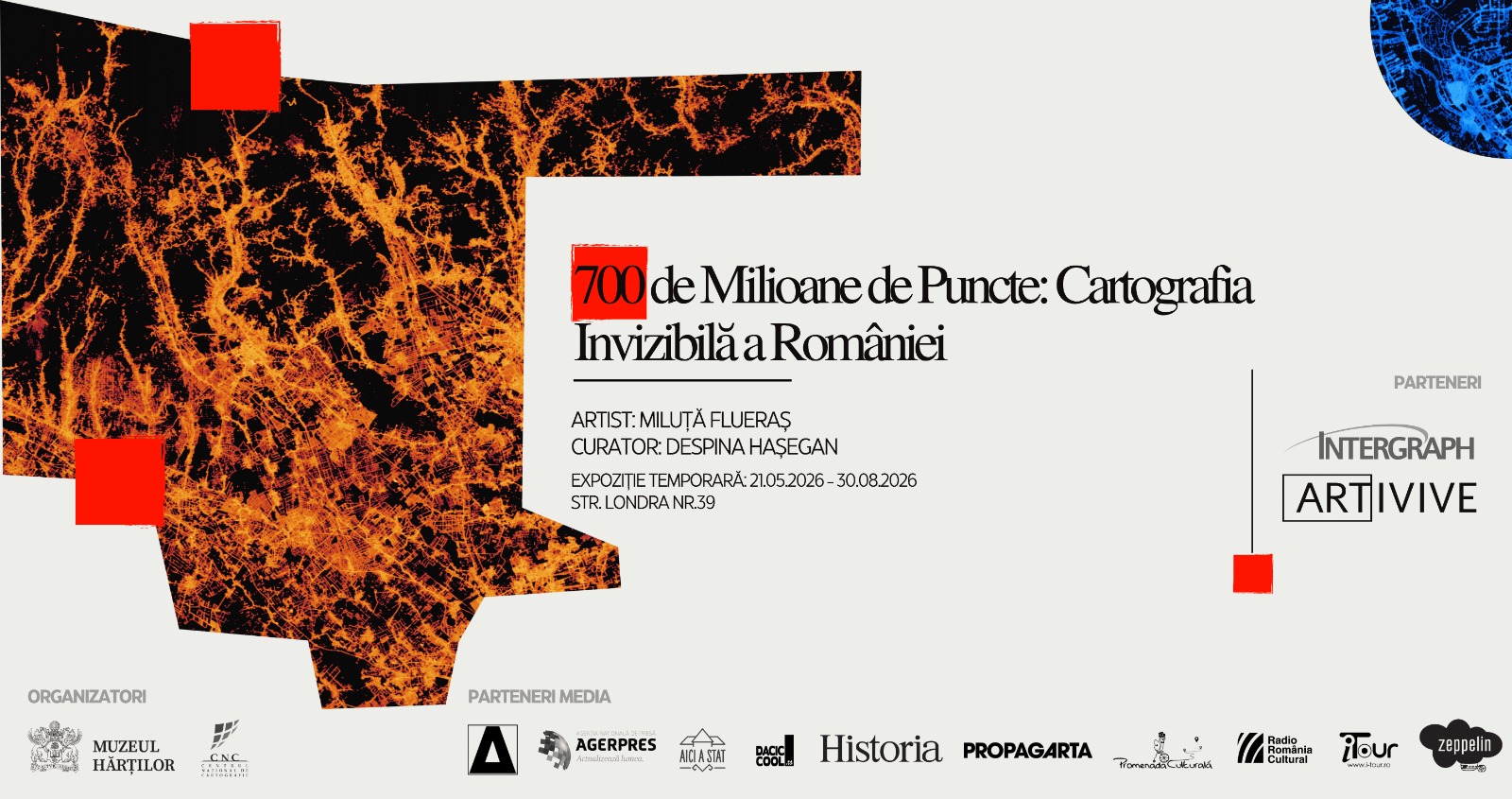
The Museum of Maps presents a groundbreaking project in the Romanian cultural landscape: 700 Million Points: The Invisible Cartography of Romania—a visual journey through eight years of geodetic measurements, transformed by artist Miluță Flueraș into works of art.
The exhibition is produced by the National Mapping Center (Centrul Național de Cartografie), in collaboration with Intergraph Computer Services, the primary technological supporter, and Artivive, providing the augmented reality component. The exhibition is curated by Despina Hașegan, museographer at the Museum of Maps.
Opening: Wednesday, May 20, 2026, at 18:00. Admission is free for the opening.
Exhibition Dates: May 21 – August 30, 2026.
Location: Museum of Maps, 39 Londra Street, Bucharest
Visiting Hours: Wednesday – Sunday, 10:00 – 18:00
Tickets: 10 lei (standard), 5 lei (seniors), 2.5 lei (students)
Tickets available online HERE
This artistic endeavor stands at the intersection of documentary and plastic expression. The raw material of the project is an invisible archive of approximately 700 million coordinates recorded between 2019 and 2026 by the ROMPOS National Positioning System. While specialists use these data for infrastructure and construction, the artist interrogates them through Big Data visualization algorithms, such as heatmaps and generative cartography. The result consists of urban “portraits” and luminous maps where the strict geometry of new neighborhoods contrasts with the organic nature of historic centers, and professional routes compose images reminiscent of neural networks.
“The data is real—each point represents a moment where a specialist required millimeter precision. But the way we present them transforms the technical into the poetic. We see flows, breaths, pulses. We see how a territory lives.” — Miluță Flueraș
The exhibition features large-scale maps of major cities, geodetic routes, and a spectacular Map of Romania. Visitors can explore maps of major cities and spectacular geodetic routes, an experience enriched by augmented reality via the Artivive app, which adds animations and contextual information to the printed images.
Miluță Flueraș uses Big Data processing techniques—such as heatmaps, edge bundling, and generative cartography—to interrogate the data:
- Urban Portraits: The strict geometry of new neighborhoods in Bucharest, Cluj-Napoca, Timișoara, Iași, and Constanța contrasts with the organic nature of historic centers.
- National Pulse: The map thrums along highway corridors and falls silent in the mountains.
- Neural Networks: Grouped professional routes create images reminiscent of river basins or biological synapses.
The project belongs to the data art current – art created from massive datasets – and proposes a different cartography of territory, drawn through its own figures. ”This is the first time Romania contributes to this movement with national geodetic data, and we are glad to host the exhibition at the Museum of Maps. While our permanent collection gathers old maps, plans, and panoramic city views, this project offers their contemporary counterparts forms of visual expression that draw equally on scientific data, algorithms, processing techniques, and new media.” Despina Hașegan, curator
The exhibition also highlights the infrastructure behind the art. The 700 million points were made possible by the collection and storage system developed by Intergraph Computer Services, which integrates global geospatial technologies to transform raw field signals into exploitable data.
Technical Data
Data Source: ROMPOS National Positioning System (Sistemul național de poziționare ROMPOS), National Mapping Center (Centrul Național de Cartografie – Agenția Națională de Cadastru și Publicitate Imobiliară)
Period: 2019–2026 (8 years)
Volume: Approx. 700 million GNSS RTK measurement points
Techniques: Heatmaps, edge bundling, generative cartography
Format: Large-scale fine-art prints on archival paper
Miluță Flueraș is a professional photographer who covers concerts, as well as film and music festivals. His portfolio also includes works inspired by digital coordinates and geodetic measurements, which he processes daily through his work at the National Mapping Center. He creates video productions, participates in exhibitions, and develops various photographic projects. https://miluta.ro/
Despina Hașegan is a museographer and curator at the Museum of Maps with over twenty years of experience in the cultural sector. As an Art History graduate, she perceives maps as both documents and works of art that unite the world’s geographies and histories. This perspective, enriched by her doctoral research in Cultural Studies at CESI, comes to life through her work at the museum. Here, her mission is to build fluid and natural connections between the artist, the work, and the public eager to observe and understand it.
***
Partners: Centrul Național de Cartografie (CNC), Agenția Națională de Cadastru și Publicitate Imobiliară (ANCPI), Intergraph Computer Services, Artivive
Media parteners : Ziarul News, Radio France Internationale România, România Pozitivă, Radio România Cultural, Historia, ACC Media Channel, Promenada Culturală, AICI A STAT, i-Tour.ro, daciccool.ro.